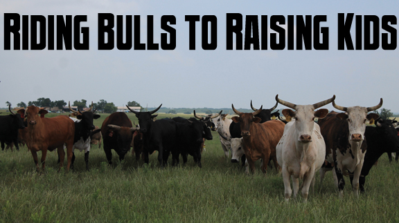
Attractions
Geronimo
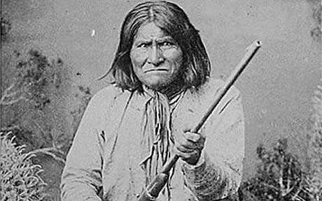
Geronimo, leader and medicine man, was the most feared, most pursued, most allusive of the Apaches and the last of the Chiricahuas to surrender.
Born June 16, 1829, in the upper Gila River country in Arizona, he was part of the Bedonkohe subsection of Chiricahua Apache, a small but mighty group of around 8,000 people.
His birth name was Goyahkla, or “one who yawns.” The source of the name “Geronimo” is disputed. Some believe it originated with the cries of frightened Mexican soldiers calling out the name of the Catholic St. Jerome when they faced Geronimo in battle. Others believe it is simply a mispronunciation of Goyahkla.
Whatever its origin, the name took on a new life long after the Indian’s death when during World War II paratroopers yelled “Geronimo” before jumping out of planes, a reference to his bravery.
By the time he was old enough to become a warrior, the Apaches were at war with the Mexicans to the south, the U.S. Government to the north, and the neighboring Comanche and Navajo tribes. By the time he was 17, Geronimo had successfully led four raids on their enemies.
Geronimo fell in love with a woman named Alope. They married and had three children. Tragedy struck while he was on a raiding trip. Mexican soldiers attacked the camp, killing Geronimo’s mother, wife and three children.
The murders devastated Geronimo. In Apache tradition, he set fire to the family’s belongings and headed into the wilderness to grieve their deaths. There, alone and crying, it is said a voice came to Geronimo promising him, “No gun will ever kill you. I will take the bullets from the guns of the Mexicans…and I will guide your arrows.”
Embolden by this knowledge, Geronimo rounded up a force of 200 men and hunted down the Mexican soldiers who killed his family. For 10 years, he exacted revenge against the Mexican Government.
Following the Mexican-American War in 1848, the United States took over large tracts of land from Mexico, including areas belonging to the apaches. With the discovery of gold, miners and settlers streamed into the land. The Apaches stepped up their attacks, including brutal attacks on stagecoaches and wagon trains.
Chiricahua Chief Cochise could see what was coming, and in a move that greatly disappointed Geronimo, called a halt to his decade-long war with the Americans and agreed to the establishment of a reservation for his people on a prized piece of apache land.
Within just a few years, in 1874, Cochise died, and the Federal Government reneged on its promise and moved the Chiricahuas north so settlers could move into their former lands.
This further incensed Geronimo, and he set off on a new round of killing. With his followers, he raided across the Southwest, becoming something of a legend. Newspapers closely followed the Army’s pursuit of him.
Authorities finally caught up with him in 1877 and sent him to San Carlos Reservation. For four long years he struggled with reservation life, finally escaping in 1881.
At one point nearly a quarter of the Army’s forces—5,000 troops—were trying to hunt him down.
Geronimo surrendered to General Cook in January 1884, but as they neared the fort, tales of impending trials and hangings caused him to escape with about 150 men, woman and children.
He again surrendered to Cook on March 4, 1886, in Sonora, Mexico, but again he bolted.
Finally on September 3, 1886, he surrendered to General Miles, the last Chiricahua to do so. He was promised to be returned to his beloved Arizona, but that never happened. Over the next several years, Geronimo and his people were moved around, first to a prison in Florida, then a prison camp in Alabama and finally to Fort Sill in Lawton, Oklahoma.
Although a prisoner, Geronimo did travel outside Fort Sill frequently, appearing at fairs, exhibitions and other public functions, selling pictures of himself, bows and arrows, buttons off his shirt, and even his hat. He appeared in several Wild West Shows, and shot a buffalo for a roundup staged by 101 Ranch.
In 1905, Geronimo’s biography was published.
In 1905, Geronimo also appeared in the inaugural parade for President Theodore Roosevelt. Still a prisoner, he was accompanied by guards wherever he went.
On the reservation, he did some farming and joined a church, but was ousted for gambling.
While riding home one night in February 1909, his horse threw him, and he spent the night out in the cold. A friend found him the next day, and Geronimo died six days later of pneumonia, his nephew at his side. He was almost 80 years old.
“I should never have surrendered,” Geronimo, still a prisoner of war, said on his deathbed. “I should have fought until I was the last man alive.”
Geronimo is buried in Beef Creek Apache Cemetery on Fort Sill among family. His tomb is covered by a cone-shaped monument made of round stones topped by a granite eagle. It bears the simple inscription, “GERONIMO.” A short path leading to the tomb is covered with pennies left by visitors in tribute to the last of the great Chiricahua Apaches.
Read more in the April 2020 issue of Oklahoma Farm & Ranch.

In the heart of the 1930s, amid the Great Depression and one of the worst droughts in American history, the central plains of the United States became the backdrop for a crisis that left millions of acres of farmland devastated. The Dust Bowl wasn’t just a period of bad weather—it was a consequence of environmental mismanagement, economic desperation, and unpreparedness on a massive scale. It remains one of the clearest warnings in American agricultural history about the costs of forgetting how to work with, rather than against, the land.
While the images that often come to mind are of blackened skies, desperate families, and abandoned fields, the lessons reach far beyond the Panhandle and remain startlingly relevant today. Whether you’re running a large operation or managing a backyard garden or small herd, the core truth is the same: soil is a resource, not a guarantee. And if we don’t take care of it, we will lose it.
What Set the Stage
The Dust Bowl didn’t come out of nowhere. It was decades in the making. Beginning in the early 20th century, settlers flooded into the Southern Plains, drawn by promises of fertile soil, good rainfall, and land made available by the Homestead Act. By the time World War I increased the global demand for wheat, thousands of acres had been plowed under and put into production.
The land these new farmers encountered had been covered in native prairie grasses for centuries—plants with deep root systems that anchored the soil and held moisture through dry seasons. But those grasses weren’t seen as valuable. They were replaced with wheat, corn, and cotton. Tractors, stronger and faster than teams of horses, made it possible to farm more land more quickly. What followed was a dramatic change in land use with little thought given to how fragile the soil might be without those native plants.
During the wet years, the gamble paid off. Farmers saw high yields, bought more land, and borrowed heavily to expand. But the good weather was temporary, and by the time the 1930s arrived with a crippling drought, the damage had already been done. The soil had no protection. There were no roots to hold it in place, no moisture to keep it settled, and no plan for what to do when the rain stopped coming.
Life During the Dust Bowl
The Dust Bowl era began in earnest around 1931. Over the next several years, the Great Plains endured a nearly unbroken string of drought, high temperatures, and relentless wind. With millions of acres laid bare, the wind picked up the dry, loose topsoil and carried it for miles—sometimes hundreds of miles. The worst dust storm, known as “Black Sunday,” hit on April 14, 1935. It turned day into night and dropped an estimated 300,000 tons of soil over the eastern states.
Oklahoma, particularly the Panhandle, was one of the hardest-hit regions. Families did what they could to protect themselves. They hung wet sheets over windows, stuffed rags under doors, and wore handkerchiefs over their noses and mouths. But nothing kept the dust out. It coated food, filled lungs, and blanketed every surface. Children developed dust pneumonia. Cattle died with stomachs full of sand. Crops failed, wells ran dry, and the ground cracked open.
For many, the breaking point came not from a single storm, but from the relentless accumulation of hardship. Crops couldn’t be harvested, and without income, mortgages couldn’t be paid. Banks foreclosed on farms. Families loaded up what they could and headed west. The term “Okie”—originally just shorthand for someone from Oklahoma—became a label for the displaced and desperate.
Writers like John Steinbeck captured the human cost of the Dust Bowl in books like The Grapes of Wrath, but no novel or photograph can fully convey what it meant to live through those years. Still, from those struggles came a growing realization: something had to change.
Recovery and Reform
In response to the unfolding disaster, the federal government took unprecedented action. In 1935, the Soil Conservation Service was created, now part of the USDA’s Natural Resources Conservation Service. Its goal was simple but ambitious: teach farmers how to work the land in ways that would keep this from ever happening again.
Extension agents went farm to farm with practical advice. They introduced contour plowing to reduce runoff, encouraged planting windbreaks of trees to slow the wind, and advocated for strip cropping—alternating rows of crops with protective vegetation. In some places, marginal land was retired from agriculture altogether and converted back to grassland. These changes didn’t yield instant results, but they began the long process of restoring the land’s health.
By the early 1940s, rainfall had started to return. World War II increased the demand for farm products again, but this time, lessons from the Dust Bowl influenced how that demand was met. The soil conservation movement had taken root, and with it came a new understanding: soil health is national security.
Preventing Another Dust Bowl
Today’s farmers face a different landscape, but the fundamental challenge remains the same. The land still has limits. Modern conservation practices are built on what was learned during the Dust Bowl and have continued to evolve. No-till and minimum-till systems preserve soil structure. Cover cropping adds organic matter and keeps the ground protected between harvests. Rotational grazing mimics the patterns of native herbivores, promoting plant diversity and healthier pastures.
Federal programs still offer support through the NRCS, helping landowners implement conservation plans tailored to their operations. Education is more accessible than ever, with local conservation districts, university extensions, and farmer-led groups all sharing knowledge.
And yet, the risks remain. Climate change is intensifying weather extremes—longer droughts, stronger storms, unpredictable seasons. In many ways, the Dust Bowl wasn’t a one-time freak event. It was a warning. And the land is still watching.
Small Scale, Big Responsibility
You don’t have to farm a thousand acres to feel the effects of erosion or drought. Even a backyard garden, a hay pasture, or a few acres of cropland can tell the same story on a smaller scale. If you’ve ever seen water pool up and run off instead of soaking in, or watched wind pull away the top layer of your soil, you’ve seen the early signs.
The lessons of the Dust Bowl apply to all of us:
Don’t overwork the soil. Too much tilling breaks down structure and leaves it vulnerable.
Keep it covered. Whether it’s cover crops, mulch, or native grass, bare ground is a risk.
Respect the limits of your land. Plant what makes sense for your environment, not just what’s popular.
Observe and adjust. Healthy land requires ongoing attention, not just seasonal effort.
Even if you only run a few head of cattle or tend to a small plot of vegetables, your soil matters. So does your stewardship. The Dust Bowl showed us what happens when the land is treated as an endless resource. But it also showed us how quickly things can begin to heal with care and commitment.
We can’t control the weather. But we can control how we prepare for it. And perhaps the most important lesson of the Dust Bowl is this: it’s easier to protect the land than it is to fix it after it’s broken.
References
USDA Natural Resources Conservation Service. “History of NRCS.”
Oklahoma Historical Society. “Dust Bowl.”
PBS American Experience. The Dust Bowl by Ken Burns.
University of Nebraska-Lincoln Drought Center.
Library of Congress – Voices from the Dust Bowl Project.
Steinbeck, John. The Grapes of Wrath.
Worster, Donald. Dust Bowl: The Southern Plains in the 1930s.
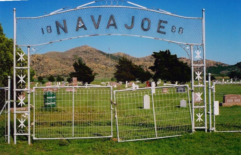
Southwestern Oklahoma is rich with history and has a beautiful, rugged landscape. A lesser known mountain range, the Navajo Mountains sits in eastern Jackson County, just to the north east of Altus.
There, at the base of those mountains, used to be the town of Navajoe. It’s easy to surmise that the town took its name from the nearby mountains. As a side note, from my research, it seems that the Navajo Mountains got their name because of a failed Navajo raid. According to folklore, the Navajos attempted to steal Comanche horses, and were annihilated by the Comanches. Legendary Comanche Chief Quanah Parker gave a detailed account of a similar failed Navajo raid in 1848 or 1849, against his village in Elk Creek just north of the mountains.
Approximately 40 years later, in 1886 when the area was still part of Greer County, Texas, two men named W.H. Acers and H.P. Dale opened a general store in the area. The next year, “Buckskin Joe” Works, a Texas land promoter, attended a Fourth of July picnic in the area. The celebration included settlers, cowboys, and several Comanches led by Quanah Parker.
That same year, the town received a post office designated as “Navajoe” to avoid confusion to Navajo, Ariz. Around the same time the Navajoe school opened, and a couple churches were founded.
Eventually the town was home to more than 200 families, and had a booming trade center, complete with grocery stores, hardware stores, saloons, a blacksmith, a dry goods store, a hotel, and a cotton gin. It was a regular frontier time.
Unfortunately, in 1902, the railroad eventually bypassed Navajoe, ensuring its demise, as most businesses moved – buildings and all. Less than two decades later the Navajoe School was consolidated with Friendship and other school districts. Now, all that remains of the town is a small cemetery at the foot of the mountains. A granite monument, which was fashioned in 1976, pays tribute to the old town.
Eventually, in the mid-1960s, Friendship and Warren schools consolidated. The new school, which graduated its first class in 1964 and is still active in Jackson County, is called Navajo.
Read more in the February 2020 issue of Oklahoma Farm & Ranch.
Sources
Wikipedia.com
RedDirtChronicles.com
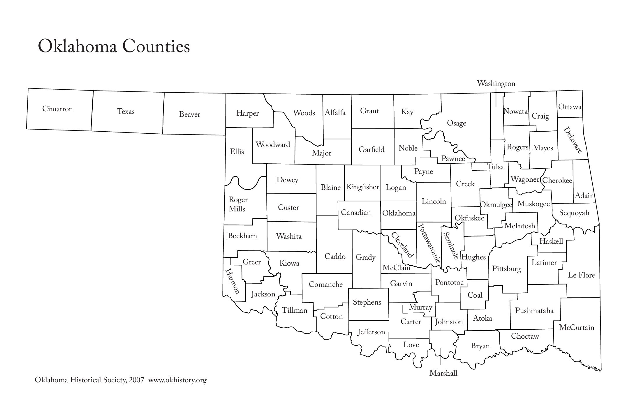
Each spring, Oklahomans can regularly be found listening to the radio or watching the television as weathermen and women report severe weather locations. Counties are typically used to identify storm locations, and while some names are easy to understand, others make us wonder.
While Oklahoma is ranked twentieth in size, it is seventeenth in the number of counties with 77. When it was first organized as the Oklahoma Territory, it had seven, which were designated numerically. When additional counties were added, they were given letters of the alphabet. When Oklahoma became a state in 1907, all the counties were renamed, with only two additional counties being added after statehood.
Oklahoma has 13 counties named for Indian tribes, and well-known Indian families have provided names for eight other counties. Six counties are named for U.S. Presidents, while rivers provided names for four counties. Military officers and Indian leaders are also honored.
Read on to learn what we found out about the etymology of our state’s counties.
Adair County was specifically named for Watt Adair, one of the first Cherokees to settle in the area.
Alfalfa County was formed at statehood as Woods County. The county is named after William H. “Alfalfa Bill” Murray, the president of the Oklahoma Constitutional Convention and ninth governor of Oklahoma.
Atoka County honors a Choctaw Chief named Atoka.
Beaver County was given because of the presence of many beaver dams on the Beaver River, which runs through the area.
Beckham County was named for J. C. W. Beckham, who was Governor of Kentucky and the first elected member of the U.S. Senate.
Blaine County is the birthplace of voice actor Clarence Nash, the voice of Disney’s Donald Duck. It is named for James Blaine, the Secretary of State under President Harrison.
Bryan County was named for Democratic politician William Jennings Bryan.
Caddo County was named for the Caddo tribe who were settled here on a reservation in the 1870s.
Canadian County in the central part of the state is named for the Canadian River.
Carter County was named for Captain Ben W. Carter, a Cherokee who lived among the Chickasaw.
Cherokee County is named for the Cherokee Indian Nation.
Choctaw County’s name is derived from Chahta, the mythical founder of the Choctaw people.
The westernmost county in the state, Cimarron County contains the only community in the state that observes the Mountain Time Zone and is named for the Cimarron River.
Cleveland County was named after U.S. President Grover Cleveland.
Coal County was named for the mineral that was then the major product of the region.
Comanche County was named for the Comanche tribe.
At statehood, the area which is now Cotton County fell within the boundaries of Comanche County. It split off in 1912, becoming the last county created in the state; it was named for the county’s primary crop.
Craig County was named for Granville Craig, a prominent Cherokee farmer who lived in the Bluejacket area.
Creek County got its name from the Creek Nation, whose country following Indian removal included the county.
Custer County was named in honor of General George Armstrong Custer.
Delaware County was named for the Delaware Indians who had established a village in the area prior to the arrival of the Cherokees in Indian Territory in the 1830s.
Originally created in 1891 as “County D,” voters in an 1898 election chose the name Dewey County, honoring Admiral George Dewey.
Ellis County was named for Albert H. Ellis, vice president of the 1906 Constitutional Convention.
Garfield County was named after President James Garfield. Prior to the Land Run of 1893, Garfield County was named O County.
Garvin County was named for Samuel J. Garvin, a local Chickasaw rancher, merchant and banker.
Grady County was named for Henry W. Grady, an editor of the Atlanta Constitution and southern orator.
Grant County was named County L in Oklahoma Territory at the time of its opening to non-Indian settlement. A county election renamed it for U.S. President Ulysses S. Grant.
Greer County is named for Texas stateman and Lieutenant Governor of Texas John Greer.
Harmon County takes is name for Judson Harmon, governor of Ohio and U.S. Secretary of State.
Harper County was created from the northwestern part of Woodward County and named for Oscar Green Harper, who was clerk of the Oklahoma Constitutional Convention.
Haskell County is named in honor of Charles N. Haskell, who was the first governor of Oklahoma.
Hughes County was named for W. C. Hughes, an Oklahoma City lawyer who was a member of the Oklahoma Constitutional Convention.
It’s unknown which Jackson Jackson County was named for: President Andrew Jackson or Confederate General Stonewall Jackson.
Jefferson County was created at statehood and named in honor of President Thomas Jefferson.
Johnston County was named for Douglas H. Johnston, a governor of the Chickasaw Nation.
Kay County was originally designated as county “K.” Kay County is the only county to keep its same name as the Oklahoma area moved from a territory to a state.
Kingfisher County was formed in 1890 and named Kingfisher by a vote of residents.
Kiowa County was named for the Kiowa people.
Latimer County was created at statehood and named for James Latimer, a delegate to the state Constitutional Convention.
Le Flore County honors a Choctaw family of French descent named LeFlore.
Lincoln County was named for Abraham Lincoln, the sixteenth president of the United States.
Logan County was named for John Logan, Federal general in the War Between the States, and a U.S. Senator from Illinois.
Love County was named for Overton Love, a prominent Chickasaw farmer, entrepreneur and politician. His descendants built the nationwide Love’s Travel Stops.
Major County was named for John Major, a member of the Oklahoma Constitutional Convention.
Marshall County was named to honor the maiden name of the mother of George Henshaw, a member of the Oklahoma Constitutional Convention.
Mayes County took its name for Samuel Houston Mayes, a teenage Confederate cavalryman, and mixed-blood Principal Chief of the Cherokee Nation.
McClain County pays homage to Charles M. McClain, an Oklahoma constitutional convention attendee.
McCurtain County was named for an influential Choctaw family that lived in the area.
McIntosh County is named for an influential Muscogee Creek family whose members led the migration of the Lower Towns to Indian Territory and served as leaders for generations.
Murray County was named for William H. Murray, president of the Oklahoma Constitutional Convention and later a Governor of Oklahoma.
Muskogee County was named for the Muscogee (Creek) Nation. The official spelling of the name was later changed to Muskogee.
Originally designated as County P, Noble County was renamed for John Willock Noble, then the United States Secretary of the Interior.
Nowata County’s nameis derived from a Delaware word “no-we-ata,” meaning “come here” or “welcome.”
Okfuskee County is named for a former Muscogee town in Alabama, from which the Creek were removed to Indian Territory, that in turn was named for the Okfuskee, a Muscogee tribe.
Oklahoma County is one of seven counties in the United States to share the same name as the state it is located in (the other six counties are Arkansas County, Hawaii County, Idaho County, Iowa County, New York County, and Utah County), and the only one of the seven to contain the state capital.
Okmulgee County is named after a Creek town of the same name in Alabama, from which the Creek were removed to Indian Territory. The name Okmulgee is derived from the word okimulgi, meaning “boiling waters.
Osage County is the largest county by area in the state and is named for and is home to the federally recognized Osage Nation.
Ottawa County was named for the Ottawa Tribe of Oklahoma.
Pawnee County is named for the Pawnee tribe, which settled in the area following the War Between the States.
Payne County was named for Capt. David L. Payne, a leader of the “Boomers.”
Pittsburg County got its name because county leaders believed that its coal production compared favorably with Pittsburgh, Pennsylvania, at the time of statehood.
Pontotoc County was named for an historic Chickasaw tribal area in Mississippi.
Pottawatomie County got its name for the tribe that lived in the area. It’s name is a Chippewa term that means “people of the place of the fire.”
Pushmataha County was named for Pushmataha, an important Choctaw chief in the American Southeast.
Roger Mills County got its name for Confederate office and U.S. senator from Texas.
The area of Rogers County was named the Cooweescoowee District at the time of statehood, but the residents protested. It was renamed for Clem Vann Rogers, a prominent Cherokee rancher and father of Will Rogers.
Seminole County is named for the Seminole Nation, whose capital is also the county seat of Wewoka.
Sequoyah County was named to honor legendary statesman and creator of the Cherokee syllabary, which brought literacy to the Cherokee Nation.
Stephens County was named for Texas politician John Hall Stephens, who championed for Oklahoma statehood.
Texas County was named for its neighbor to the south.
Tillman County was named for U.S. Senator Benjamin Tillman of South Carolina.
Tulsa County was named after the previously established city of Tulsa and the Creek village of Tulsey Town in Alabama.
Wagoner County is named for the county seat of the same name, which derived from Henry “Big Foot” Parsons.
Named for President George Washington, Washington County is the second smallest county in Oklahoma.
Washita County is named for the almost 300-mile long river that runs through it and empties into Lake Texoma and the Red River.
Woods County was named after Samuel Newitt Wood, a renowned Kansas activist, legislator, and newspaper publisher.
Woodward County was originally known as “N” County and was composed of present-day Woodward County and portions of Harper, Ellis, and Woods County. It is unknown exactly whom the county (and the town) is named after, but the two leading candidates are Brinton W. Woodward, a Santa Fe railway director, or Richard Woodward, a buffalo hunter.


-
 Country Lifestyle2 years ago
July 2017 Profile: J.W. Hart
-
 Attractions9 years ago
48 Hours in Atoka Remembered
-
 Equine9 years ago
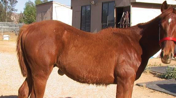
Umbilical Hernia
-
 Farm & Ranch1 year ago
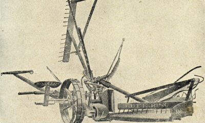
From Plow to Plentiful: The Most Important Inventions in Agricultural History
-
 Outdoors8 years ago
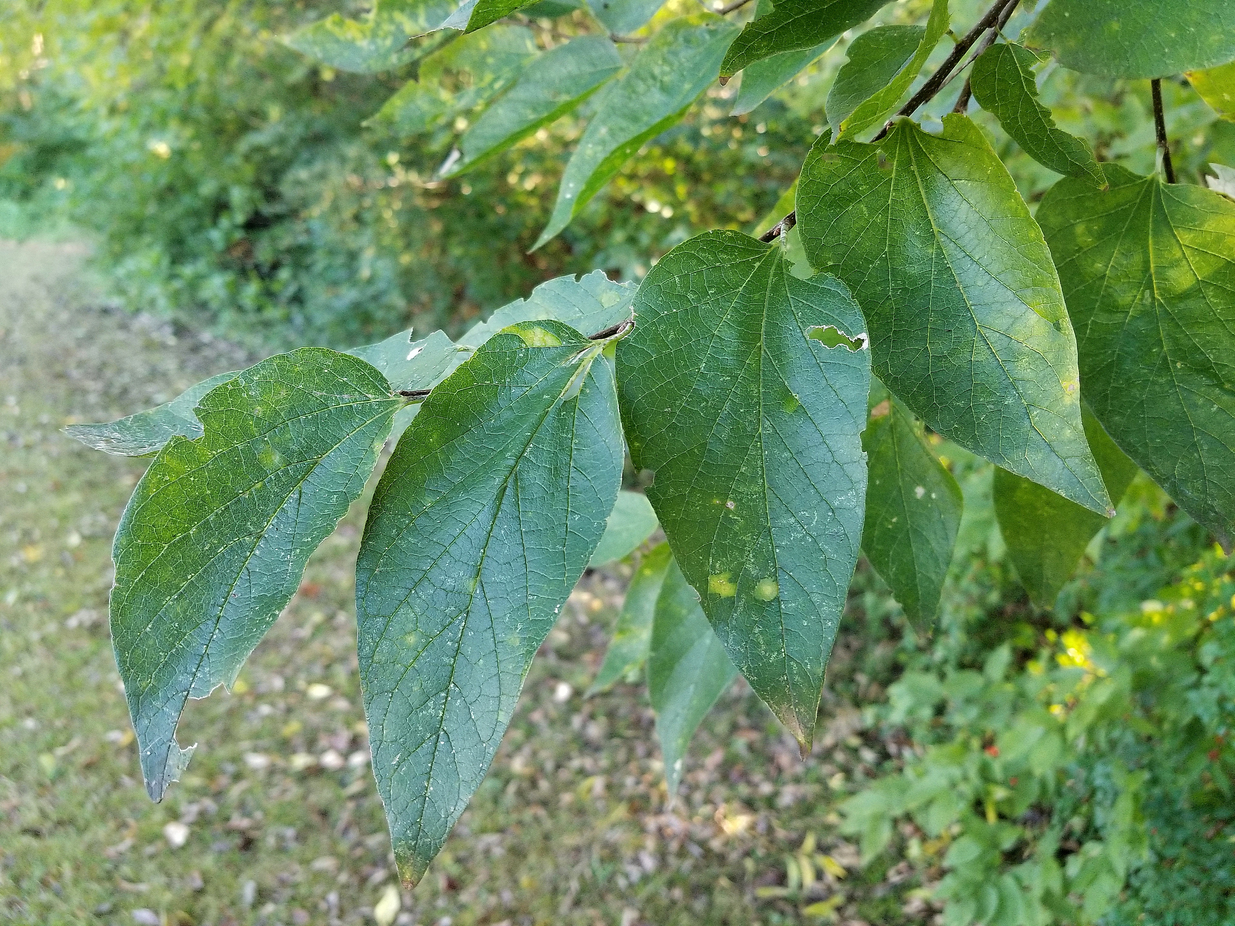
Grazing Oklahoma: Honey Locust
-
 Country Lifestyle5 years ago
The Two Sides of Colten Jesse
-
 Farm & Ranch8 years ago
Hackberry (Celtis spp.)
-
 Equine6 years ago
On the Road with Emily Miller-Beisel